Understanding precision, accuracy, and tolerance of geospatial datasets: an example based on the usage of GNSS receivers
Main causes of GNSS positioning errors
The main sources of positioning errors are:
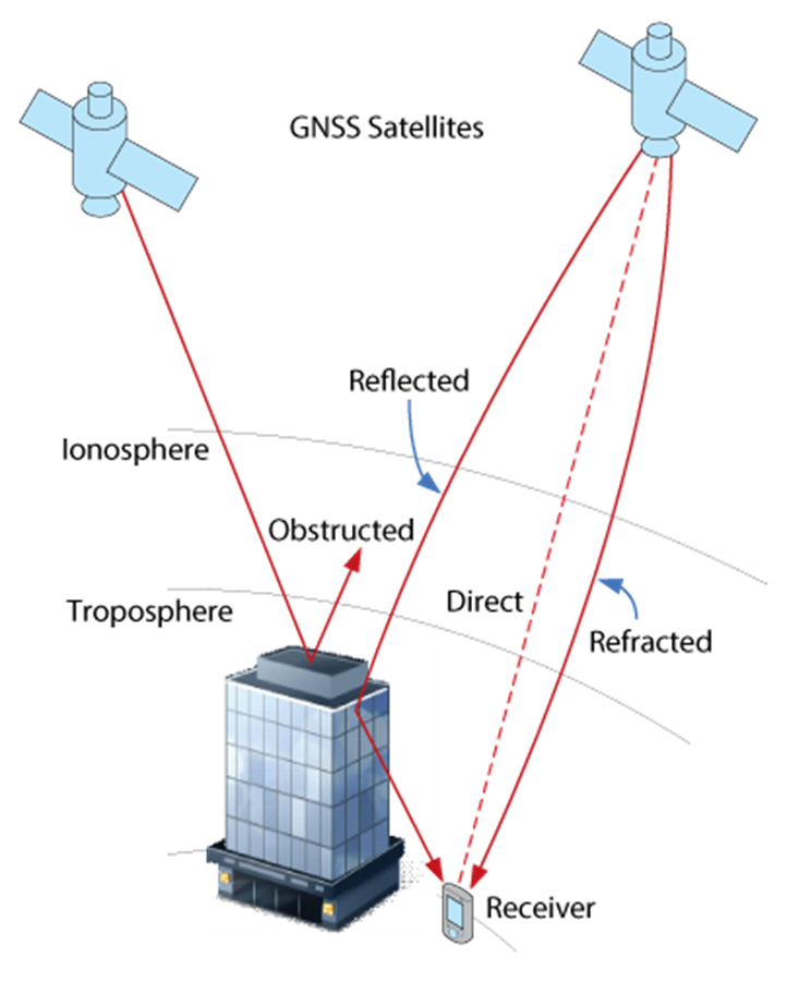
- Atmosphere “bending” (Figure 6):
- in the ionosphere (layer between 75 to 1000 kn above the Earth surface
- it contains electrically charged ions that may cause a delay in GNSS signal speed
- ionospheric delays are difficult to predict (depending on solar activity, the time of year, time of day or location, etc.)
- in the troposphere (the lower layer with a thickness varying between 8 and 20 km above the Earth surface)
- tropospheric delays are related to temperature, density, pressure and humidity conditions
- in the ionosphere (layer between 75 to 1000 kn above the Earth surface
- Multipath propagation (Figure 5) caused by signals reaching the receiver after being reflected from an object (e.g. a building facade)
- Satellite errors are very small but, as the signal travels at the speed of light (30 cm/ns, 1 ns = 10-9 s), they effects may not be negligible:
- on-board clock are atomic ones and therefore very precise (but not 100%)
- orbits may drift outside operating limits, causing satellites being taken out of service until the orbit is recovered using satellite rocket boosters
- Receiver errors: receiver clock, antenna, etc.
- Number of satellites
All those errors combined determine that GNSS receivers mounted in non-professional devices (smartphones, tablets, sport watches, etc.) have a metric positional accuracy (± 5 m).
Three major techniques allow to reach centimetric positional accuracy:
- averaging of repeated observations at the same location (the least efficient method)
- modeling of the phenomenon that is causing the error and predicting the correction values (very complicated)
- differential positioning: to overcome both satellite and atmospheric errors a reference station also known as a base station, can be used. A base station is a GNSS receiver installed at a fixed and precisely known location, estimating GNSS errors and sending them in the form of GNSS corrections to the user receiver. Base station and the user receiver are located close together and therefore “see” the same errors
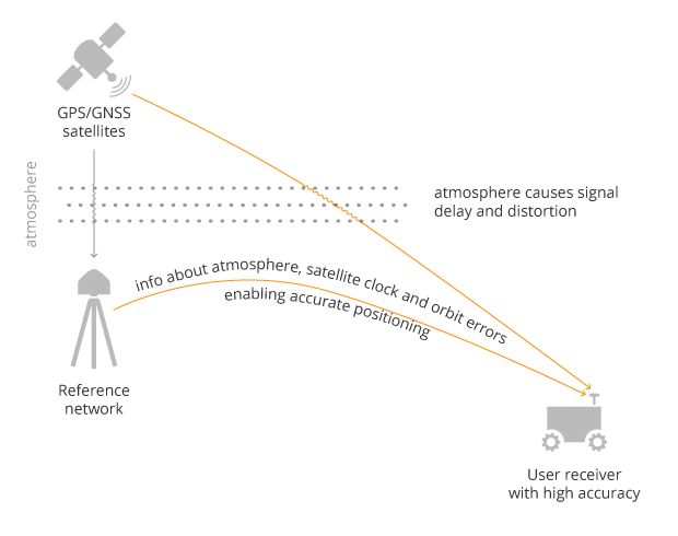
Interconnected reference receivers spread over an area sending real-time correction using cellular phone networks constitute a reference network (RTN):
- SPIN3 is a Regione Piemonte, Regione Lombardia and Regione Autonoma Valle d’Aosta service composed of 33 permanent stations that provides multi-constellation (GNSS) corrections. It is a free service
- ITALPOS is a subset of a worldwide commercial service
Visits: 68233