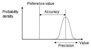
Understanding precision, accuracy, and tolerance of geospatial datasets: an example based on the usage of GNSS receivers
How GNSS positioning works
The following 5 steps are involved in GNSS positioning:
- Satellites: GNSS satellites orbit the earth. The satellites know their orbit ephemerides (the parameters that define their position in orbit) and the time very, very accurately. Ground-based control stations adjust the satellites’ ephemerides and time, when necessary.
- Propagation: GNSS satellites regularly broadcast signals containing, among other data, date and time of the emission, as derived from the satellite atomic clocks, satellite position (ephemerides), as well as their status. Signals are modulated according a pseudorandom digital sequence, unique for each satellite of the constellation(s). GNSS radio signals pass through the near-vacuum of space, then through the various layers of the atmosphere.
- Reception: GNSS user equipment receives the signals from multiple GNSS satellites then, for each satellite, recovers the information that was transmitted and determines the time of propagation, the time it takes the signals to travel from the satellite to the receiver. It can do this because of the pseudorandom nature of the signals (the receiver knows the pseudorandom code for each satellite). Modern receivers can recover signals from multiple satellites in multiple GNSS constellations.
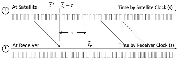
- Computation: GNSS user equipment uses the recovered information to compute time and position. The position is estimated by calculating the distance to each satellite by multiplying this propagation time by the speed of light
- Application: GNSS user equipment provides the computed position and time to the end user application, for example, navigation, surveying or mapping
Visits: 66956